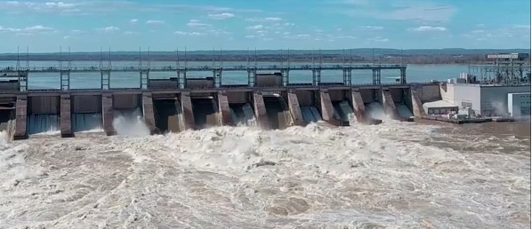
I am sure most people in Ontario have heard about the flooding on the Ottawa River this year, and I am also sure most had deep heart-felt sympathy for those people standing in the water, piling sandbags in on effort to save their homes or their neighbours. It brought out the true Canadian in the many people who rallied to help strangers save their homes. The soldiers were also a very welcome relief when they were brought in, but as much as they helped, it was their pleasant demeanor and “let’s get it done” attitude that brought hope for victory with them.
However, that wasn’t the attitude that Prime Minister Trudeau and his environment Minister Catherine McKenna brought to the disaster. They came to prove a point about climate change and tell people to smarten up and move out of the flood plain. Every interview done on the flooding included their message of “I told you so”.

The facts, however, tell a different story. First of all, if you have a dam in a river, then whoever put that dam in place is responsible for how high the water rises, not mother nature or whatever 100-year event they may claim was the cause. If you look at the Ottawa River from Ottawa to Montreal, you can soon see that it is the Carillon Hydro Dam at the Ontario/Quebec border that sets the water level in the river. That dam is at least 62 feet high, so in that wide section of the river, extending back to Ottawa, this dam stores a massive amount of water. Everyone knew early this year, that there was a lot of snow and not much melting through the winter. So, you would think that in anticipation of more water, the common-sense thing to do would be to lower the water in the Ottawa to Carillon section early. Once spring starts this cannot happen because Montreal would be flooded out when combined with the flow from the Great Lakes down the St. Lawrence.
If you check the historical data on the “Ottawa River Regulation Planning Board” site, you will find water levels and flows going back as far as 1933. You will see that someone decided to raise the normal water level in this stretch of river by about 1.38 metres starting in 1963. The Carillon Dam was completed in 1962 -draw your own conclusions. You will also see that levels in the river are still virtually the same as they were in the 1950’s in all regions of the river. One of the high mark years was 1960 and this didn’t seem to be related to climate change and didn’t cause the 100-year flood at Constance Bay that we apparently have this year. The next high level was 2017. Some other years had some fluctuation, but none with this devastation. What was the reason? According the Councillor Eli El- Chantiry of Ottawa, “this was the perfect melt”. He is right. Not warm rains in March or April. No hot spells. Just short thaws and cold freezing nights. What caused the flood? The Rideau didn’t have flooding, the South Nation didn’t have flooding. The ground wasn’t frozen, so much of slow melt was absorbed. If you look at 2016, the Carillon dam dumped water starting in January. The dumped water is measured in cubic metres per second.

As you can see by the numbers in the chart, those in charge of the dam ignored the snow load potential and didn’t start to lower the river seriously, until April instead of January. People on the river were lucky that we had such a slow thaw. If we had had a true weather event with hot days and heavy warm rains, they would have needed sandbags around the Peace Tower. Hopefully someone in the Federal Government will take this on and find out who didn’t control the dams properly. Mother nature was kind, this time. What if the same people are in charge when the real 100-year event happens?
